
Middle-school history and geography
Read Maps and Explain Change with Evidence
Is this the right resource?
- Audience / fit
- Middle-school history and geography
- Teaching or planning target
- Describe what a map shows, compare a matched area, distinguish observation from inference, and explain a limited historical claim using more than one source.
- Essential prerequisites
- Locate and read printed map labels with suitable support. Order years and distinguish a source date from an event it describes. Give a specific detail and explain its relationship to a claim.
- Preparation
- Read Start Here; choose the source details and student pages; preparation time depends on the selected route.
- Use time
- Two lessons, each estimated at 35–45 minutes, with models, guided practice, a separate check, focused response tasks and a follow-up check. Use the teacher guide to adjust the sequence for your class.
- Materials
- Printed or enlarged supplied map/source details, paper and pencil or an established response method; the source context and teacher guide.
- What to print
- Use the primary PDF choice below and its matching adult guide. Print only the phase/task being used; keep complete keys and later checks with the teacher.
Start teaching
Lessons and guided source practice · PDF (5 pages)
Read the starting and print guide · PDF (2 pages)
Complete teacher guide, answers and alternatives · PDF (11 pages)
Print only the student pages you plan to use. Keep teacher answers and later checks with the teacher until their intended use.
Browse free resources · Start with the Boston map inquiry
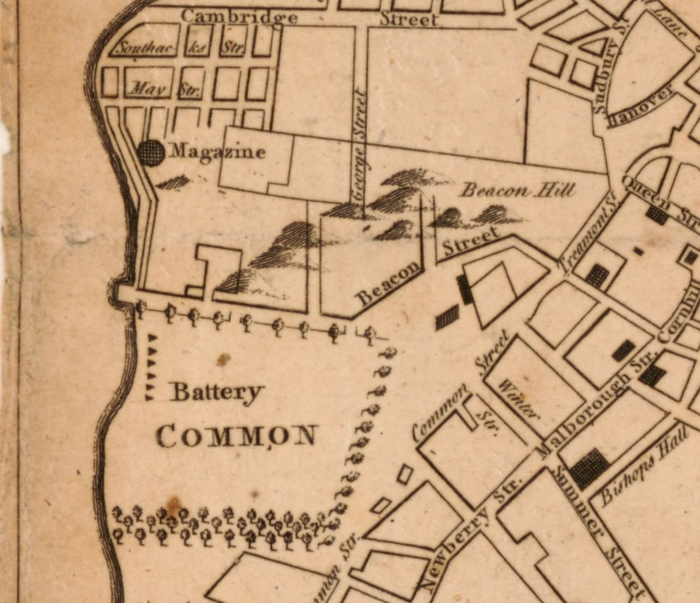
Help students read historical maps carefully, separate observations from inferences and explain change with evidence. Compare Boston maps from 1775 and 1883 with a short government report, then choose focused practice and follow-up tasks.
For grades 6–8, where students can locate map labels, order years and connect a detail to a claim. All files are free; no account or payment is required.
- Learning goals
- Describe what a map shows, compare a matched area, distinguish observation from inference, and explain a limited historical claim using more than one source.
- Teaching sequence
- Two lessons, each estimated at 35–45 minutes, with models, guided practice, a separate check, focused response tasks and a follow-up check. Use the teacher guide to adjust the sequence for your class.
- Access
- Print or enlarge the supplied source details. Read text neutrally, use the factual glossary and allow an established response mode. Record support when interpreting the student’s reasoning.
Use a response to choose the next task
Look separately at observation, comparison, evidence and limits. Clarify an unclear label or direction before deciding whether to continue, reteach or extend. The check and follow-up use different areas of the same historical maps; if a student has already seen the full map, detail or answer, use that task as practice.
Formats and all files
Student materials
Share only the selected task. Keep later checks and teacher answers separate.
- Lessons and Practice: Boston Maps and a Back Bay Report: Printable PDF · Editable Word · HTML text
- Independent Check: Mill Pond Area: Printable PDF · Editable Word · HTML text
- Continue Practice: Make a Claim Traceable: Printable PDF · Editable Word · HTML text
- Clarify the Source: Dates, Places and Blank Space: Printable PDF · Editable Word · HTML text
- Reteach: Observe Before You Infer: Printable PDF · Editable Word · HTML text
- Extend: Whose Questions Do These Sources Answer?: Printable PDF · Editable Word · HTML text
- Follow-up Check: South of Essex Street: Printable PDF · Editable Word · HTML text
- Apply Source Reading: Write a Public-History Caption: Printable PDF · Editable Word · HTML text
Teacher guides, answers and planning
- Start Here: Read Boston Maps as Historical Sources: Printable PDF · Editable Word · HTML text
- Teacher Guide: Teach, Read the Response and Choose a Next Step: Printable PDF · Editable Word · HTML text
- Source and Reading Supports: Printable PDF · Editable Word · HTML text
- Planning Record: Evidence and the Next Teaching Move: Printable PDF · Editable Word · HTML text
Choose a next move
- Distinguish an Inference from a Guess — Practice explaining how a clue supports an inference; the fictional reading task has a different context.
- Compare Two Accounts of the Same Event — Compare what two accounts actually report before judging their differences.
- Write an Evidence-Based Paragraph — Organize an evidence-based paragraph once the historical claim and source limits are sound.
- Evaluate a Web Source’s Credibility — Consider which source can support a particular question; credibility and relevance are separate.
- Objective-to-Assessment Alignment Pack — Match the historical-source goal to the actual task and evidence.
- Check for Understanding and Choose the Next Step — Use the blank next-step record with the map inquiry’s separate criteria; its worked inference example has a different target.
- Clear Directions and Language-Support Pack — Plan neutral directions and response options without supplying the map comparison or historical explanation.
- Boston Maps: Observe, Compare and Explain — Start with the two-lesson sequence, selected print pages and complete teacher package.
Sources and classroom use
The maps and report are authentic historical sources: A new and correct plan of the town of Boston (1775) and Map of Boston for 1883, from the Library of Congress Geography and Map Division; and a Massachusetts legislative report printed in 1861, from the State Library of Massachusetts. The map scans were obtained through Wikimedia Commons. The original works are in the public domain in the United States; the guide supplies source credits and reuse details.
Source images and a report excerpt are included locally, so students do not need to visit an outside site. Map details show selected areas at different scales. Compare named places and what each source depicts; do not infer exact area from their printed size or assume that the report explains every change.
You may print and adapt the original teaching materials for classroom use under the Terms of Use. Retain source credits and identify your changes. The site does not collect student responses. Report a resource issue.
When the next source question concerns government action
Trace Public Requests and Government Decisions — For a civic source-reading target, trace a public request to the institution asked to act and distinguish proposals from enacted decisions.
Editable Word files
Choose the editable files for this resource and keep teacher guidance separate.
Share this resource
Report a resource issue · Open an issue email
Do not include student names or identifiable work in an issue report. Page revision: 15 October 2026; classroom files retain their own editions.